
New York Airports
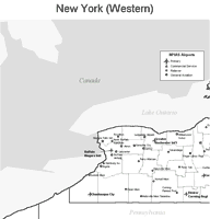
Western New York Airport Map
|
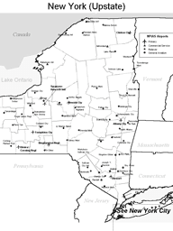
Upstate New York Airport Map
|
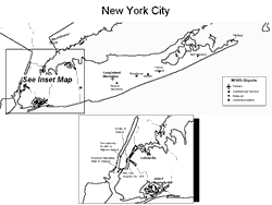
New York City Area Airport Map
|
Lower Manhattan Heliport

|
 Large hub airports in New York State include
the John F. Kennedy International Airport in New York City and
the La Guardia Airport in New York City.
Large hub airports in New York State include
the John F. Kennedy International Airport in New York City and
the La Guardia Airport in New York City.
New York State's medium hub airport is the Buffalo Niagara International Airport.
Small hub airports in New York include the Albany International Airport, the Macarthur Airport in Islip, the Greater Rochester International Airport, the Syracuse Hancock International Airport, and the Westchester County Airport in White Plains.
The photo at right shows jets on a runway at JFK International Airport.
Interactive New York Airports Map
This section features an airport locator map that can be zoomed and panned to show the state of New York and its neighbors or a small region of the state. Use the plus (+) and minus (-) buttons to zoom the map in and out, respectively. Simply swipe or drag the map to pan it in any direction. The airport markers on this New York map can help travelers find IATA-designated airports in the state and plan their air travel arrangements more efficiently.
Copyright © State-Maps.org. All rights reserved.
New York airport map source: FAA 2001-2005 NPIAS.
New York airport map source: FAA 2001-2005 NPIAS.